
Summary: A moderate to hard hike with off track sections to climb The Pilot and traverse the Cobberas range. Remote country with some rock scrambling. Plenty of Brumbies. Take water treatment.
Location: 25km NW of Suggan Buggan in Alpine and Kosciuszko National Parks
Duration: 3 days
Difficulty: Moderate
Map:
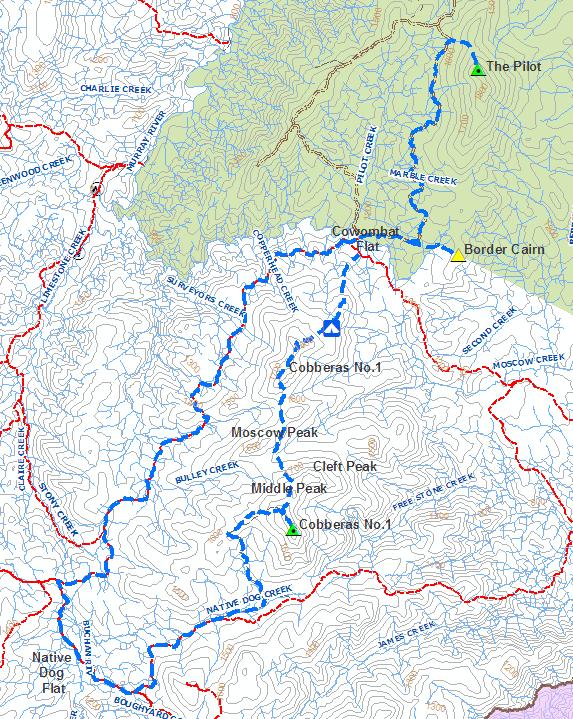
Day 1: Native Dog Flat to Cowombat Flat, Source of the Murray River and Border Cairn 1
I arrived at Native Dog Flat in the early evening on the Thursday before Good Friday just before dark. A stack of campers, horse riders and 4WDers had already staked claims and were scattered about the flat in readiness for the inundation of people that were likely to follow for the Easter long weekend. For me the plan was simple, park the car up, drink what was left of my red wine and roll the swag out for the night.
An early start was called for. I was up at the crack of dawn and was welcomed to the new day with a covering of frost over the ground. That made decision making easy – pack up, smash down some breakfast and hit the trail to warm up. No point in hanging about. Beanie and gloves on and I was off.
The distance I was aiming for day was around 17km. Basically track bash from Native Dog Flat to Cowombat Flat using the Limestone Road and Cowombat Flat Track. It was an easy walk and I absolutely flew along with my ultralight kit. I was at the gate and sign declaring entry to the Wilderness Zone soon enough. Shortly after I came across a group of 4 heading south back towards Native Dog Flat. I quizzed them about where they had been but they were a bit vague and I didn’t quite understand if they had just climbed the Cobberas from the track or made the full traverse. I was interested in what the scrub over the Cobberas would be like. Weighed down with full heavy packs, sporting sturdy leather boots and knee high gaiters the group eyed my ultralight pack and trail runners and firmly stated that the scrub was horrendous and would be extremely difficult.
They noted I was alone and were seriously concerned seeing the size of my pack and the mission I described to them. I did my best to allay their worries. Sure, I would prefer to share the experience with someone else but hell I’m not going to let the lack of a hiking buddy stop me exploring the world. If everyone just thought a bit more positively instead of fixating on everything that could wrong the world would be a better place. Hike solo occasionally people! You will love it. Anyone I moved on more determined than every to complete the mish in 3 days.
Parting ways I continued flying down the track. The track was uninspiring and despite the Wilderness Zone status it was obvious a vehicle had recently passed through. The occasional glimpse of the major features I was to cross in the coming days was great though. The thing that caught me the most on the approach track was the volume for brumby crap. It was everywhere. Just about every stream I crossed had been completely trodden, ripped up and soiled with dung on the edge of the water. If you’re hiking this country, take a water purification system. Lucky I had my trusty Sawyer in-line filter attached to my water bladder. I reached Cowombat just before 12pm.
Silver and shining in the sun against the green grass of the flat, the remains of the old RAAF Dakota (DC3) that crashed in 1954 stood out like dogs bollocks. There isn’t not much left of the wreck today. I had a quick scout around, ate lunch and found a great little camp site near the Murray River.
The Murray spilts not only Cowombat flat but Vic and NSW. The requisite jump between states and stand in two had to be done. Childish, yes, but come on admit it, everyone does it don’t they?
With time on my hands I started to bite into the next days itinerary and mad a scramble to find the source of the Murray River and the Border Cairn on Forest Hill. A short walk east up the Tin Mine Track I soon found the corner where the track heads north marking the jump off point to the headwaters of the Murray. Brumby trails led the way and made for easy walking. Love or hate them, Brumbies that is, I have a foot in each camp. The trails helped but the damaged they’ve caused in the head waters of the Murray was appalling.
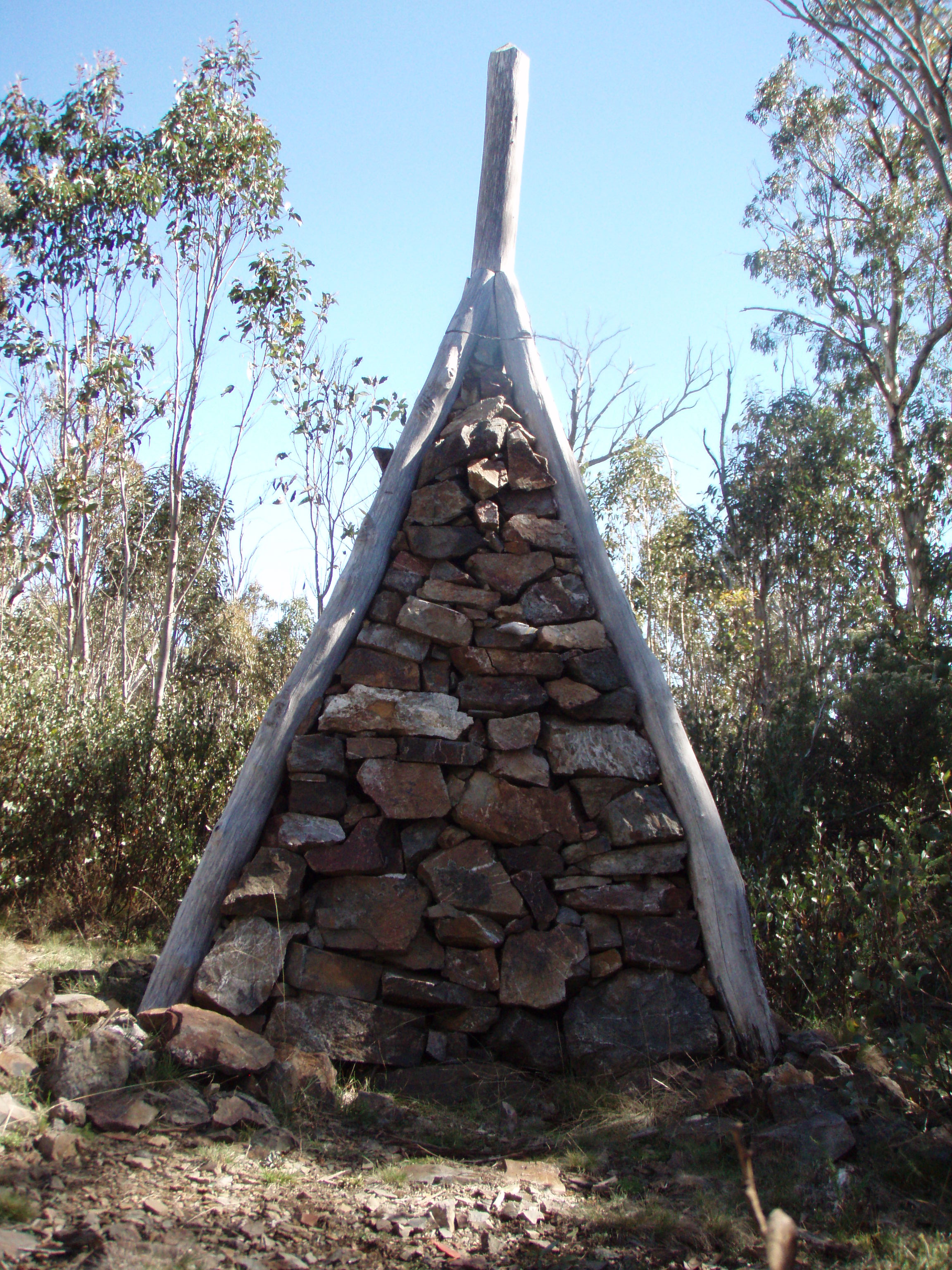 Forest Hill Border Cairn
Technically speaking I’m not sure that I found the one true spring that marks the start of the Murray but I certainly reached the point where the Black Allan Line (ie. straight line border between Vic & NSW meets it. From there I followed the lead gully and stream flow until it dissipated into nothing. I think I can mark that off the bucket list. A foot pad, human or horse made I couldn’t gauge but definitely used by horses, led the way along the border to the top of Forest Hill and Border Cairn No.1 first erected in 1869.
Trivia: The nearest point of the Murray to Cape Howe marks the border, not the actual source of the Murray River as many people think. To be precise the point of the Murray 22.5 chains NW from the border cairn.
It was an easy backtrack through the scrub and return to Cowombat Flat to set up camp and enjoy a camp fire.
Day 2: The Pilot
Who could resist a climb of a mountain named The Pilot. It sounds cool and I had to find out.
I woke to another frosty morning and an iced up tent. The views across the flat from the tent were amazing with mist lying low and frost slowly burning off the vegetation as the sun showed it’s face. Brumbies could be seen in the distance. Being on the lee side of a small rise on the eastern side of the flat my camp site received the sun last but I had no problem in staying toasty in my sleeping bag waiting for its approach.
A hot breaky was in order and I was mightly pissed off when shaken by the rolling boil and steaming under the lid my pot tipped over spilling my hotwater. Take two. The metho is a bit slow going in the cold.
Another trail bash was required today from Cowombat Flat along the Tin Mine Track. Return it would be around 17 km. As I started up the track I startled a small group of brumbies. The stallion initially stood his ground and whinnied. A few steps closer and he was off like a flash marshaling his mares away keep a close eye on my movements.
The track bash was unremarkable. Again for a wilderness area there were plenty of signs of recent traffic and rangers opening up the track from fallen timber which took away the remoteness feel for the place that I imagined. It was an easy stroll.
Following the track over the contours and across streams was straight forward and I soon found myself at a creek line that crosses a bend in the track marking the shortest section to bush bash and get to high ground. The plan was simple, follow up the gully uphill east to a distinctive saddle and follow walk south to ascend the pilot. The sun was shinning and the sky was clear.
Immediately off the track I encountered a short section of thick snowgum regrowth but it was short lived. The gully itself turned in flat area, cleared of an canopy and covered in bright green grass and small shrubs. The low ground was fairly moist and almost a bog. The presence of brumbies was obvious in the soft ground. Sneaking through the shrubs and being down wind I managed to sneak to within 20m of another pack of brumbies but a snapped twig underfoot was enough to make them take flight.
The gully floor soon turned to a jumble of broken rocks scattered with mountain pepper, leucopogan, alpine grasses and other shrubs. This made for easier walking towards the high ground. I ended up following the clearest spots of ground to sidle the saddle and emerge from the trees onto a series of craggy bluffs to the North West of the Summit Cairn. Emerging from the trees the high was noticeably up a bit and much cooler.
 The Pilot Summit Cairn
The mountain top was typical for a alpine peak at 1800 metres above the tree line with lichen encased rocks strewn about and alpine short grasses blowing in the breeze. The summit cairn stood proud on the skyline but I couldn’t see the trig point. I soon made a bee line for the cairn and joined the trig point in taking shelter from the wind on the lee side.
The views were spectacular. 360 degrees around. The Main Range to the north, the Cobberas to the south west and Cowombat Flat filling the middle ground. Again I had made excellent time to reach the summit and was well ahead of schedule. Enjoying the views while stuffing my face with gorp and salami wraps I looked across the Cobberas to spy tomorrows route. Two tall bluffs of pink granite marked the passageway through which I would walk and beyond that a series of small open flats. The was weather holding out and I had plenty of time on my hands. I made the quick decision to descend to Pilot return to camp, pack it up and start the ascent of the Cobberas to one of the small flats.
It took around an hour and half and I was back at Cowombat Flat. I threw my gear into my pack, stocked up with water and began the climb. It was around 3:00pm by the time I was off and I estimated a good two hours before it would get dark.
I crossed the flat and began climbing a spur line running south from the horse yards at Cowombat. Good decision to start the climb late in the afternoon and not first thing in the morning as It wouldn’t have been a pleasant start to the day at all. Immediately off the flat and into the trees the terrain was steep and the vegetation thick. Surrounded by thick wattle regrowth and spikey shrubs I battled for a kilometer or so. It didn’t take long to be saturated in sweat and questioning my decision to complete an off track traverse across the range.  As I climbed through the two pink granite towers though the terrain began to thin out at around 1400m and become more alpine like. The wattle dissipated but the heaths remained. Grass and rock covered the rock and Multiple rock scrambles were required to negotiate upwards towards the flats.
I made the first opening around 4:30 and pressed on to scout a better site. I sound found it, set up camp, cooked dinner and was in bed before the sun went down. The day was as long as these trip notes are becoming.
Day 3: Cobberas traverse
With around 20km today with the first half of the day completely off track it was an early start. I drank a lot of water last night and running a little short so I opted for a dry breakfast of muesli bars and a handful of scroggin. I wasn’t quite sure what the water situation would be light across the Cobberas range and wanted to keep as much with me as possible. I had around 1.5 Litres.
Camp was packed up and I was on my way by around 8:00am. Looking towards the Cobberas I could not see a thing as the entire mountain was covered under a thick layer of low lying cloud and fog.
The scrub wasn’t as bad as I anticipated and I found that I was making very quick time. The vegetation was mostly knee high heaths and grasses underneath the open snow gums. From camp I initially followed a open grassy flat SW for around 400m before diving into the bush and starting an ascent towards the hill marked 1697m.
A hundred meters along I disturbed another mob of brumbies. There are so many in this area – unbelievable. Their tracks assisted a lot in negotiating a path uphill and through rocky areas and made the going much easier.
 Approach to Cobberas No.2
It didn’t take long to reach hill 1967 and then the saddle south of this peak. Soon I was picking my way through rocky crags and scrambling on all fours in several spots. Another quick ascent and I was on top of Cobberas No.2 at 1929m. I was completely enveloped by the fog and the cold wind on the exposed summit bit into my thinly layered clothes.
It took a little route finding and some easy rock climbing to scramble down off the south side of Cobberas No.2 and head south towards the saddle below Moscow Peak. It was difficult to pick out the topography and find the saddle to aim for in the cloud so it was down to relying on the trusty compass and keeping an eye on weather I was descending or sticking to the flat ground.
The cloud had lifted a little on the approach towards Moscow Peak and I was mesmerized by the cliff lines I could see in front of me. I would love to come back here to climb some of the lines but it’s a hell of a long way in with climbing gear. Maybe when I have more time on my hands. The ochre rock rose steeply from the contour and was just a little too tricky to be attempting solo with no gear. So it was that I had to sidle around the base of the cliffs sticking to the flatter and open ground.
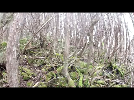 Tea-Tree thicket
At one point I looked up to see an impenetrable wall of dark vegetation in front of me. Honestly you couldn’t see through it. I was not looking forward to bashing through but as I got closer I found it to be a minor creek-line occupied by tea tree. The thick canopy when view from higher up seemed impenetrable but the going was actually quite open and easy. A small trickle of tannin stained water meandered underneath the spongy tangled mess of moss covered roots. I stopped to take a few photos but the light was tricky and I couldn’t captured the magical scene that my eyes saw on the point and shoot camera. I was getting low on water but the creeks water flow was just a little too shallow and slow moving. Knowing I wad approaching Moscow Creek, supposedly a reliable water source, I held out.
I continued on and was stopped in my tracks again when I saw a Southern Boobook Owl directly at head height roosting on a branch metres from me. It was completely unfazed by and stayed where it was as I took off my pack to retrieve my camera. We continued to stare at each other for quite a few minutes and I was able to get within about 3m of it before it took flight. The encounter was fascinating and unlikely to have occured if I’d been walking in a group instead of solo.
The scrub became a little thicker and the amount of fallen timber increased as I sidled the southern edge of the Moscow Peak escarpment and approached the saddle above the Moscow Creek headwaters. Soon the scrub cleared completely and another flat grassed area favored by brumbies appeared. I was looking forward to collecting water from the Moscow Peak headwaters but was completely put off by yet more brumby damage along the creek. Just about every soak, pool or bank had been trampled, cut up by hooves and spoiled by horse crap. Appalling. I’m sure I could have scrub bashed further off the saddle and down the creek line to source clean water but I chose not to. I had enough to continue on.
There was one more decent uphill run left for the day before the ground would flatten out. From Moscow Creek towards Middle Peak the going was tough. It was relatively steep climb, gaining 200m elevation over a 500m distance. The heathy scrub was thick and spikey. Thousands of tiny leaves and needles pricking through my pants. My legs looked like pin cushions following this leg of the journey. On of the down sides to going ultralight – I was using ankle gaiters to keep rocks out of my shoes and that was about it. If I were to do this trip again I would take thicker and knee length gaiters despite the added weight.
Again brumby tracks helped significantly. At times when I lost a foot pad I had to summon my inner equine and think where would the horses go. Sure enough a track would appear through the path of least resistance. Frequent stops were required up this ascent to catch my breath.
 View north from Middle Peak
Finally I had made it and the ground leveled out. I quickly scrambled to the top of the escarpment between the Cleft and Middle Peak for spectacular views back across the route I had taken. By now the cloud had cleared but the wind was still up and bitterly cold. I stopped to take some video footage of the panorama but didn’t hang around long in the wind. It was deafening.
The final leg was in front of me and I had made fairly fast time. Middle peak looked to very climbable but I wasn’t sure would be present itself on the southern tip. If there were sheer cliffs then climbing down was going to be dangerous. An easy decision to sidle around the west side of Middle Peak was made. I had finished my scroggin and looking forward to lunch on the top of Cobberas No.1. From Middle Peak there was a short climb through open country towards the Cobberas No. 1 ridgeline. Once on top the walking track was easy to pick up and made for a very quick run towards the Trig point.
I made the trig point at Cobberas No. 1 at around 12:30. The usual lunch of salami and cheese wraps was knocked down and washed down with most of the remaining water. I left 500ml for the run back to the car. The obligatory summit photos were taken as light showers of rain began to come in from the west. The summit log book box did not have a top and the logbook itself was damp and staring to decay with mold. Without a pen I didn’t sign the book.
 Cobberas No.1 Summit
Mission accomplished. Well almost. I had climbed The Pilot and traversed the Cobberas Range ultralight and solo. Now I just had to make it back to the car. On a high from summitting I flew down the walking tracking and didn’t really stop until hitting the Playgrounds Flat. Another 1km along the flat and I was soon on the road. The remainder of the trip was a road slog back to Native Dog Flat and uneventful. It was a big though and I glad to finally reach the car and get stuck into my clean water. What an awesome trip. A couple of notes for other hikers wanting to do this trip:
- Take a water treatment system either a filter or chemical treatment.
- Wear long gaiters for off track sections.
- If you are car shuttling leave one car at Cowombat Flat Track and another at the Playgrounds to cut out the road bashes required at the start and end of the trip.
- Enjoy!

Good for you! Loved your blog. I get excited and inspired to hear about others that love to explore this magnificent plant we live on.
Hey mate cool vid…
way to go….
solo walking is where its at.
day one – one walks thru the forest
day two – one becomes the forest
Hey Mick
Loved the write up. Looks as though you came South along the Cobberas Range- definitely saving the best for last! The perspective from your ultra wide lens was superb. I haven’t been up there for a while, but I seem to recall that in between No1 and Cleft Peak, there was a flat grassy saddle with water nearby, good for camping.
Solo is good- although sometimes I find it can be a bit too good- I did a trip recently and stayed up on the remote mountain for 3 nights, (instead of doing a circuit) having to trek for water each day. This was for photos of different spots as the light was changing, you only get a few precious minutes of that magic light.
It’s been a dry kind of season this year- water up on the tops has been way less than normal.
Keep the trips and posts coming- always a pleasure to stop by and read!
Pete
Thanks Pete. Stay tuned. Off to Larapinta and Mt Zeil in 2 weeks. Cooking up a storm for dehydrating tonight.
Mike I just loved reading this account of your traverse. I did something similar back in September 1985 solo (its the only way to go😁) and an summit image of that trip can be found on my fb page “Photography by Wade” in the Wild Australia folder.
I found it so sad to read about the destruction of the region by wild horses, fire and the proliferation of 4WD’s. I observed none of this on my earlier ventures. 😔
I now live in Townsville Nth Qld and am finding an entirely new environment to explore.
Thanks for the Blog Mick have done the full run through by 4WD official trip with SMA part 1988 we went from Deadhorse gap through tine mine Cowombat Flat and then down through the 9 mile to the Snowy and pinch river to Jindabyne it was a day trip, Wow in later years i got involved in SOTA summits on the air its a program that started in England ham radio operators there decided that they needed way to get hams off there bums they dvised a system if you where of able limb you would go out and climb the Mountains the higher the mountains you would be awarded 10 points for Mt above 1600M
8 points for Mt 1400M -1200M it goes on the old hams at home got the same points as the activator the activators are the mountain Goats the guys at home are the chasers if you go to http://www.sotawatch2 you will find all the info there
since being inveigled in2013 -to the present I have climbed 134 or the mountains in the Snowy mountains region there are ony 42 left its a terrific hobby i would like to do the great Alpine walk get a group to do it we have a Group on facebook Roof top of Australia Huts and Trails drop by and see us all the best Rod