
Summary: A rather lengthy description of our SW Cape Circuit
Difficulty: Moderate – Hard
Timing: Jan 2012
I had been eying this hike off for years and was determined to complete it this year. And what a way to start the New Year.
When planning trips I usually put the feelers out to friends to guage if anyone else might be interested in joining me and in this case there wasn’t much joy to start with. No-one could get the time off work or people had other plans. But I never let this put me off and was looking forward to going solo.
As luck would have it a crew of 4 was put together at the last minute – a teacher, a forester, an engineer and myself (forest fire fighter). I’m no stranger to the SW and knew what we were in for but I wasn’t sure that the rest of crew quite understood the hike ahead, so I resolved to have a pre-trip planning lunch. I did what I could to enliven the group’s imaginations with the legends of the SW – long days, knee deep mud, creek swims, off track bush bashing etc… to see if anyone would opt out. None were dissuaded from tackling the SW Cape and so off we went.
Looking at the forecast, we made the easy decision to keep the wind on our backs as often as possible and decided to complete the circuit anti clock wise.
Day 1: Hobart – Melaleuca – Pasco Creek Ridge
I knew we wouldn’t get away from Melaleuca until around 10:00-10:30 and it would be a very late day indeed if we aimed to get to Noyhener Beach on the first day (with an early start, if walking in the usual clockwise direction, most walkers typically make it from Noyhener to Melaleuca in a day). The estimated 17km and 11 Chapman hours for that section was going to take us a wee bit longer. It would be more than a test for the teacher who had a bit of a bung knee. I knew the forester would be up for the challenge but the engineer was an unknown quantity. So the plan for the day was to get to Horseshoe Bay, get the swims out the way and see how far along the ridge adjacent to Pasco Creek we could press along.
It was a pleasant flight into Melaleuca although a bit rough for some. It took the teacher many hours to get over the nausea. We were treated with clear views over Federation Peak, the Western Arthurs, Precipitous Bluff and much of the south coast. Setting down at little after 10am it was a beautiful clear sunny day and light winds. Grabbing fuel from the pilot we were off north up the airstrip and onto the Port Davey Track. The track was as dry as I had ever seen it with very little mud to speak of. We each took turns setting the pace and settling into the hike, allowing the back and shoulders to get used to carrying a pack again. We took a quick lunch stop near Woureddy Creek and the teacher did her first repairs on blisters starting to form.
Heading North West on the PD Track it was great to come around the low hills and have the ridge line we were aiming for and hill 374 come into view. The way ahead was clear to see. Soon we arrived at the point to turn off the PD Track and enter the untracked country to head into Horseshoe bay.
A short bash through some thick tea tree and sword grass and we on the waters edge. The tide was out, making for easy walking around the edge of the bay. Soon enough we reached the first creek crossing. I had talked this up and everyone was prepared to bag their packs, strip down and swim. The channel was too deep to wade straight across but we found we could walk 40m or so straight out into the Bay where the river channel was only waist deep. Somewhat of a relief but myth one of the SW busted – I thought we would be swimming for sure. Creek crossings two and three were much the same – wading out into the bay it was easy to find a shallow enough crossing.

The day was getting on and the crew, new to the SW, found the going tougher than expected. A reality check for all. “Welcome to the South West guys.” No stopping though. We still had ground the cover. We pushed onto the ridge adjacent to the Pasco Creek to see how far we would get for the day. Not that far. Stumps were pulled up around 6pm opposite hill 44.
Packs thrown off, it was time to set up the tents. Imagine my surprise when the tent I was to share for the remainder of the trip came out. Not that price is an issue but quality certainly is, particularly for this neck of the woods. Now don’t get me wrong I’m sure the classic $45 Wildcountry Escape from Rays Outdoors is a perfectly fine tent for its intended purpose but I don’t believe the manufacturer had the South West in mind when selecting materials or design. And particularly after a pre-trip planning session:
Me: “Are you sure you have a tent that will be suitable for the conditions down there? It can get wild at any time. I can take my bomb shelter if you don’t.”
The forester: “Yeah its fine. We’ll take my tent”.
No turning back now – we were stuck with it. I considered sleeping under my tarp for a minute or squeezing into the tent that the teacher and engineer are sharing. Water. Dinner. Bed. The first day down was awesome and spirits are high.

Day 2: Pasco Creek Ridge – Pasco Range – South West Cape Range – Noyhener Beach
3am and we are woken by thunder, lightning and big old fat rain. Sure enough the Wildcountry Escape doesn’t quite cut the mustard. A NW wind rips into the sides and forces the poles down on top of us. The forester is on the weather side, I have the vestibule on the lee side. The forester tries to hold the poles and tent up with outstretched arms and legs. A comical sight. Nothing else to do but turn his back into the weather and try sleeping. Yeah right. Staying dry is impossible. Soon enough it’s raining inside the tent as the fly is pressed against the inner. The walls collapsed around us.
With lightening cracking down around nearby hills the other guys decide to make a move off the ridge. I count. 1,2, 3…13, 14, 15. It’s far enough for my liking and I hunker down into my bag waiting for sunlight. It doesn’t come quick enough. With no letup in the rain the decision is an easy one. We aren’t getting any drier and it’s time to get up regardless of the sun. “Welcome to the South West guys! Did I mention torrential rain?”
A quick breaky. We pack up as the rain eases. Time to get moving in the hope that an early arrival at the next sheltered camp site will provide some opportunity to dry our gear out. We make good time in the easy low veg following the main ridge line. Staying on the high ground the route ahead is clear enough despite the threatening clouds. Rain is intermittent as we follow the rough foot pad up to hill 216. Quick photo stops as the views back across the flats to Horseshoe Bay are fantastic. Heading west we begin the climb to the top of hill 374. I was expecting much of this circuit to be off track in the proper sense but SW myth 2 is shattered as there seems to be a well-defined foot pad the entire way. I try to encourage the crew to spread out as we climb the hill, but humans being humans we like the easier path where others have passed before. Still the climb is steep and not easy. The rain comes down hard again. The first signs of mutiny appear as the true reality of walking in the SW hits home for those new to the area. I’m sure their were thoughts of turning around by some before too far in.
At the top of hill 374 we are hit face on with hard rain, followed by hail and then sleet driven in sideways by a fierce wind. We back off the immediate top and wait for a break. Incredibly enough it comes literally a minute or two later and the sky clears for the remainder of the day. I’m still amazed by how rapidly this place changes. Reaching the western side of hill 374 the route ahead is obvious with the foot pad standing out clear as day following the spur line past Hannant Creek and up on to the South West Cape Range beyond. Lunch at Hannant Creek.

Frequent breaks are required to take it all in. A foot pad comes and goes across the high ground. We fan out. At the top of hill 256 the first signs of the ocean are spied. Excitedly we set out across the open ground. The foot pad becomes obvious again down the spur line and following the edge of a large of patch of veg. It’s a steep spur but easily navigated. I encounter the first snake at the bottom of the spur, a tiger and my heart skips a beat. Initially it refuses to move but responds to the few well placed stones. It darts off into the scrub. I’m re-joined by the crew and take up a position at the rear. The next couple of km’s follow across the undulating ground towards Noyhener Beach. Easy walking over fairly open ground. The odd thicker patch of bush along creek lines need to be crossed.

We reach the final high ground and see the sand blow out and knob 34 indicating the way to the beach and camp. The ridge line is followed around to the south (left). We lose the foot pad but are eager to reach camp and punch through the thick tea-tree to the sand beyond. It doesn’t take long to reach the beach. Huge surf pounds down and the ocean is covered by white caps. Winds are high but it’s sunny. We wade Murgab Creek, climb the ladder and locate camp. A sheltered spot in amongst the trees. Very comfortable with beach furniture.
The winds are perfect for drying tents and other gear. Plenty of time to play and explore the beach. A swim in the ocean was also in order and incredibly pleasant, not cold at all. Who would have though given the start to the day. Plenty of flotsam from fishing vessels had strewn the beach. Lots of photos taken.

An impressive dinner of spicy panner and cus cus for mains and stewed fruit and custard for desert, washed but by the obligatory cup of tawny port. The sun is not setting until past 9pm and we milk the light for all it’s worth.
Day 3: Noyhener Beach – Window Pane Bay
A late start and a bit too much faffing around has the tide positioning to beat us. There are heaps of blue bottles washed up on the beach. No sign of these yesterday and a good thing given the swim the previous afternoon.
I was led to believe that the route initially follows the rocks along the coast, past the dense veg to a rocky inlet where it then heads inland. I’m sure it does and we give it a crack but hit a small cove that is slightly over hanging, making it difficult to negotiate around thr rocks with packs on and an incoming tide. No-one wants wet feet just yet. There is nothing for it. We climb steeply up the rock and scramble over low heaths into the tea-tree above.

We pick a route through the dense tea tree heading SW, weaving in and out, sometimes crawling for short distances but it doesn’t take long to pick up a faint route. No foot pad as such but plenty of fishing debris markers that have been hung in the trees indicating people had gone this way before. Mixed feelings about this. The marked trail makes for easier navigation but takes away from the feeling that you’re exploring new ground.
Soon we are out of the tea tree and onto the open ground again. A foot pad becomes obvious and the odd steel picket starts to appear marking the route. The white rock of the foot pad stands out against the veg and it’s easily seen. Fairly easy walking although the track climbs steeply in and out of a few gullies before climbing up and sidling to the west side of hill 274.

Getting hungry we search for a suitable spot out of the wind for lunch. We all suffer a case of just over the next ridge. We top out on the high ground south of Hill 274 and can see Window Pane Bay. We jump off the ridge out of the wind and enjoy lunch with a view. The South West Cape towers above the coast and it dawns on the crew that “yes we are going to descend to the beach and climb up and over that range tomorrow.”
Descending to Window Pane Bay is initially easy to Island Bay but soon gets into the thicker tea tree and scrub on the descent to the beach. The 500m or so through the forest seems to take forever. Roughly 100m to the beach the teacher encounters snake 2, another suspected tiger. We get to the beach and find another pleasant, sheltered camp site opposite Window Pane Creek.


We spend the afternoon wandering the beach, swimming and taking photos. The range above is covered in cloud and scattered rain. A sign of things to come?
As we prepare dinner a tired group of 3 wander into camp. A big day for these guys indeed. Compass navigation in the clouds along the range, intermittent rain and strong winds from the NW (straight into their faces). Tomorrow will be a big day and I gee the crew up. An early start will be required. Fuel up, hydrate and prepare feet for a massive effort. Not much water on the range. The forester prepares Kangaroo curry for dinner. I teach the crew to play 500. Early to bed.
Day 4: Window Pane Bay to Wilson Bay via South West Cape Range.
An early start is called for if we are going to make it across the range. At 15km and 8 Chapman hours, I predict it will take us 11 to 12 at the rate we have been going. The route through the forest is open, enjoyable and easy enough however soon climbs steeply out into the open and back up to the South West Cape. I walk behind to push everyone when required to keep the pace ticking over.
Stopping for a short break we see two small yachts on the water and take this a sign that the weather will hold out for us. Pushing on we continue to climb. “Once we’re on the high ground it will be much easier going.” I hear the teachers muffled cries on the steepest sections as her knee screams out to stop but there is no turning around now in the middle of nowhere. The teacher is a fighter and does well to push through to the top of hill 374. We stop for a well-earned rest. Still a long ways to go. We can now see ocean on two fronts.

We lose the foot pad but stick to the high ground and zig zag up the steepest pinch to hill 504. The views back north are fantastic. So far we have lucked in with the weather. There is a light wind that cools the sweat and the visibility is awesome with views back across to Stephens Bay and beyond.
I keep promising great views at the top of the next hill but the false summits keep coming. We stick to the high ground and tick off hills 504, 588, 639 and 687. The weather holds out. The views just kept getting better. We could see the SW Cape and the route ahead. The SW Cape Range seems to go on forever.

No-one anticipates the steepness of the descent off hill 687. We all grin and bear it. It is taking its toll on the teachers knee but she troops on. I’m not a fan of descents (unless it’s on a mountain bike) and remedy the situation by charging down, the theory being it’s over quicker. It’s important we get a move on along the range while the weather is good and the walking OK. I knuckle down aiming to reach 601 by 1pm for lunch. I don’t look back for a long time and find myself 20mins out in front of everyone else when I reach Hill 509. We are going slow but there is nothing that can be about it. I find a rock slab and have a nap waiting for the crew to catch up.
A quick lunch. We ascend 601 and the urgency is put back in to everyone’s step as the route ahead stands out and the reality of how far we are walking today sinks in. I discuss with the forester that it’s pretty standard for groups to be clouded in up here, hit with severe weather, forced to navigate in the white out, bunker down or retreat altogether. We certaintly have it good but we agree that it is not an option to get stuck up here in the Wildcountry Escape.

The views are spectacular and heaps of photos are taken. I cannot believe our luck with the weather! It was a blessing to find a tarn up high as I’m nearly out of water. A refill is in order and we start to rehydrate tonight’s dinner.
Hill 554 is reached and we can see the way to Mt Karamu and the ridge down to Wilson Bight. Still a long way to go and it’s close to 4pm.

We pick a route and head west aiming just below hill 370. Various footpads come and go. We fan out. Regrouping we head towards Mt Karamu. The engineer and forester charge off. We climb up Mt Karamu for the view. The wind bites cold but the sky is clear and the ocean calm. We look sou-south-west towards the SW Cape itself. It is so close but we don’t have the time or inclination to push further down the cape for better views. Wilson Bight beckons us down to the shore to bath in the cool waters and ease the tired legs. The spur line down looks very steep!

And it is incredibly steep. My usual tactic is employed and I explode down the hill, planting my walking poles down using them as additional legs. The track gets tight and in several sections requires the nimble skills of a gymnast to get over, under and around the fallen trees. Soon enough I’m down but well in front of the crew, a relief to be over the range and on the way to camp. I wait for the others on the rocky shore, tired and spread eagled on the ground. The surf pounds in.
I know there are two camp sites at Wilson Bight but I’m not entirely sure of their location. Like any good camp site I’m assuming they will be close to the beach, close to decent water and will have a good view. We cross over the first small headland separating the rocky beach from the sand and cross a small creek. Not the best for drinking so we move on. We come to a second creek that is not much better but has an amazing camp site close by. Spacious, protected and a great view. Recent high tides have washed away half of the steps built to reach the camp.
We are all tired and want to rest but decide that the water source is not that good and make the hard decision to continue to the next beach. Descending down to the bight we spied 2 people playing frisbie at the far end beach and are convince that it must be a better camp site. A decision is reluctantly made to push onto. A poor decision in hindsight.
Approaching the rocky headland I spy a small waterfall that is clearly fresh and will be OK to drink from but being closer to the headland than the first camp I continue on. The forester tries to shout out that we should go back to the first camp but the surf and wind drown him out and I misunderstand what he’s trying to be communicate. We’ll all tired.
The tide is coming in but I’m determined to get around the rocks to the next beach. I rock hop as much as possible but hit a point where it is impossible to climb over or to keep feet dry. It is quicker and easier to wade through the sea water. Reaching the other side there is a wide clear fresh water stream running into the bight. I’m relieved to find good water. Now just to locate a camp. We are not going any further today that is for sure. The crew is a ways off and I push to the eastern side of the beach where the track meets the beach.
I find the camp site alright but find that it the smallest camp site imaginable and that is already occupied by 4 blokes in 3 tents. There is no room at the inn. I find the tiniest space 20m up the track that may just accommodate our two tents but with a fair side slope. What else to do? We are not going any further today. I dump my pack and back track down the beach to meet the crew and break the bad news of our camp site for the night.
First the forester rounds the rocks, dry feet mind you, and take the news surprisingly well. “Wait until you see it.” Next the engineer – “that’ll be fine.” I find that they have climbed over the rocks. Good job. But the long day has clearly taken its toll on the teacher and she lingers behind the rocks. “Keep going. I have to pee. I’ll catch up.” She later confesses to managing to do the deed clinging half way up the rocks and with pack still on – too tired to take it off! ![]() I’m impressed.
I’m impressed.
The teacher is completely spent and wouldn’t care if we camped on the beach. I offer to take her pack but she refusing and soldiers on into camp like a true warrior. We’re there. It’s around 7:30pm and has taken just short of 12 hours for all of us to get into camp. I congratulate everyone for just having completed the hardest sections of one of Australia’s toughest hikes and promise the going only gets easier from here on in.
 A little gardening is required to fit the tents but they go in OK. The slope is horrendous. A well-earned hot meal and it’s time for bed. We are knackered and hoping that this will counteract the side slope. Not to be. A terrible night’s sleep it is going to be. I have to level my mattress out by placing my pack and all other unused gear under one side. Latter we were to find that in addition to a side slope we have a slight down slope enough to ensure the slippery sleeping bag material keeps loosing traction and sliding towards the bottom of the tent.
Day 5: Wilson Bight to Ketchem Bay
A sleep in is called for. We are in no hurry now. Pancakes for breakfast – yum. Everyone is impressed. Little do they know I have a better surprise for them later in the day. We only have a couple hours walking toady and take our time. Soak in the sun, swim, eat, dry cloths and basically gather some strength back. We get away at 12pm.
Initially the track is properly benched out, has small bridges over gullies and stone step work. It makes for easy going. But it does move back into thick over grown narrow green tunnels that we have become use to. That’s all good. An uneventful hike over the Amy Range.
We reached the beach and find that our friends from the previous night have made home at the first camp site on the western side of Ketchem Bay. I know there is another camp on the western side of Ketchem Creek further along and we head for it.

The camp is roughly 100m back from the beach on edge of Ketchem Creek. A sheltered spot with great views out towards Ketchem Island and the dark tannin stained waters of the creek. The only drawback, plagued by mozzies but manageable – what do you expect near water.
I follow the creek north to collect water. Snake encounter number three. This one is the biggest, fattest, well fed black snake I have ever seen. It slinks off leisurely .
We lounge about at camp and I set about providing a well-earned treat for everyone – fresh cooked chocolate muffins. No-one has seen this done on the trail before and pay close attention to see how it’s done. A crowd pleaser for sure. What better way to spend a lazy day than with a cuppa and a muffin. A swim is in order and the forester tries his luck at finding abalone. No joy.

There is virtually no wind and the tannin stained creek water takes on a mirror like quality, reflecting back perfect images.
Day 6: Ketchem Bay – Hidden Bay – New Harbour
Another easy days walking. There are no regrets in doing the circuit anti-clockwise. All the hard stuff is out of the way and we are able to cruise back to Melaleuca. We find the track at the eastern end of Ketchem Bay and follow the exposed white rock of the track up onto the ridge line.
Once on top we find the old track that heads NE straight across the Middle Bluff Ridge line is closed for rehab. Fair enough. We have no shortage of time and I’m sure everyone appreciates the easier grade of the new track. I have mixed feelings about the new track. It has obviously been well constructed, drains well and provides great access for a large number of people but to me it is just not the same as the off track or small foot pad walking that we have been doing. The winds are incredibly strong up high and a massive contrast to the beach at Hidden Bay.

We reach Hidden Bay early in the day and are hit with the calmest, clearest, turquoise waters seen thus far. With the sun out, white sand gleaming one would be forgiven for mistaking this place for the a tropical beach. The only prop missing were the palm trees. At times it is eerie with the water so calm there is virtually no sound of the breaking waters.
The mid-morning swim and lollop on the beach extends into morning tea and then lunch. We linger for as long as possible but eventually move up the beach and out the back of the sand dunes, continuing on to New Harbour.
We follow the low ridge between Hill 33 and 43 without much fuss but find the climb up through the forest steep. The cool gullies capture our attention as we meander through. The infinite small details and patterns of the mosses, fungi and ferns are amazing. We come out of the forest and into the open country again and my thoughts are elsewhere. Dark clouds threaten from behind and the wind picks up again. I can’t decide between shell jacket on or off. The well-formed track sidles around the back (N side) of the hills and makes for fast going, which is a good thing as the rain starts down again. A penny for the thoughts of the Dutch fella we pass walking in the opposite direction on the track, walking straight into the weather.
We reach the beach and locate a large camp in the open forest in the Middle of New Harbour, then set about making camp while keeping dry. The tarp goes up and becomes the communal hub for cooking, eating and some card playing.
Not impressed with the water quality near camp the Engineer and I follow the creek up to find a clean undisturbed section with a bit of flow and without a smell. We go about 300m but the creek remains on the flat ground and doesn’t seem to flow any faster. There are many holes where we can fill up but all are flat water and none look that inviting with lots of growth in them. Nearing the end of the hike and with plenty of fuel we decide to boil what we collect. We walk back with water but we needn’t have bothered as the rain buckets down. Sticking pots under the run off from the tarp they quickly fill and we have a clean source of water.
The rain doesn’t ease. We sit and wait. Cooking food and drinking tea. Who knew that deep fried mountain bread would actually taste pretty darn good. Not to mention with the hikers version of bruschetta dip. And Banana puddingcooking in a double boiler – oh yeah.

The rain comes and goes and we fill the day wondering the beach, taking photos and making beach sculptures. We initiate a 5th member into our clan – Grug.
Day 7: New Harbour – Melaleuca
An unexciting walk given that it’s our last day in the SW and we have to face work again in a day or two. We need to reach Melaleuca by 4pm to meet the plane and have plenty of time to cover the ground but something inside says that, that is not going to happen. A large low pressure trough moved over area last night and doesn’t look to be moving off any time soon. The winds are picking up.
The track becomes typical SW track with water running down the middle and filling any holes on its way down. Soon we come across the true muddy sections. This is what I was expecting from day one. There is nothing for it but to plough straight in and stick to the track. Besides it’s our last day here right? Hot shower, fresh cloths and a warm bed tonight yeah? Um… no
We make good time to the South Coast Track intersection and stop for a breather. Looking West, the skies are black with low clouds, rain not far and it’s heading for us. By the time we hit the duck boards we are getting smashed by heavy rain and strong winds. The trudge up the duck boards was just that. Everyone just wants to get to Melaleuca now and walks as quick as they can.
We reach Melaleuca in gale force winds and are met by the Parks Volunteers who tell us that all planes have been grounded since yesterday. We are stuck at Melaleuca for the night. Damn, no fresh socks tonight. But wait… didn’t we eat all our left over food yesterday to fill the day in. Holy crap. And what if the weather doesn’t improve tomorrow or the next? And our plane connections back home? Can’t do anything about any of that now. Time to get settled into the walkers huts. At least we will have a dry night.
Our afternoon of cards was broken by thoughts of what we would do for dinner and then breakfast. Then a knock on the hut door. The incredible volunteers had cooked up a fresh batch of hot damper and presented it to us with jam and butter. Wow!!! How could we every repay for that. Just by enjoying it was their answer as they then placed fresh cooked felafel’s in front of us. OMG. How incredibly kind. Thank you so much.
 We watch for planes and for the a break in the weather. It never comes.
We were joined by a fellow walker who had enough of the weather and had left his party at Ketchem Bay to seek the comfort of the huts for a couple of days and to collect a food drop. The same groups of guys from Launceston we had been sharing the back end of the hike with. He joined us for cards and promptly offered up a bottle of tawny port from the contents of his food parcel. Wow. The kindness of strangers. So cards, nipping on port and reading the entertaining hut log it was for the afternoon.
Packet soup, 2 squares of mountain bread and vegemite and a cup of tea for dinner. Breakfast was not looking much better. Early night. Hail on the roof and gale force winds.
Day 8: Melaleuca to Hobart
A very unexciting breakfast of mountain bread, vegemite and a cup of tea. Would we get out? I’m down to a tin of smoked muscles, a packet soup and an energy gel. The winds aren’t letting up. The clouds are still low and very dark. The rain keeps coming intermittently.
I pack my pack early in the anticipation of a flight getting in. Those stinky wet socks and shoes are put on one last time. Waiting, waiting, waiting. At 10am I move my pack down to the registration hut and am joined by everyone else shortly. Nothing to do but wait some more. Snooze. There is no letup in the weather. Every time it clears and the cloud lifts it comes back in just as rapidly as it would go.
I start to hear things. Is that a plane? No, it’s just a fly whizzing by my ear. Is that a plane? No, it’s a boat engine.
At 12pm there is movement at the station. The Parks Volunteers and two photographers we also met yesterday are heading towards us with packs on and gear in a wheel barrow. The volunteers have heard via the UHF that there is a 1 hour window of opportunity around 1-2pm in which Par Avion will have a crack at flying in. We all wait nervously.
Spot on at 1 pm the wind completely drops off. For the first time in days I can hear frogs and birds and noises other than wind. The cloud clears and the sun comes out. It stays like that for a while. 2pm comes and goes. Still no plane. The weather starts in again. Light rain and cloud. Was that it? Was that the window? Had they missed it? Am I having smoked muscles for dinner tonight?
Out of the cloud the low hum of a twin engine breaks through the wind and we spy the first plane. They had made it and we are out of here. It lands and is followed by a second, a single engine and a third, another single engine. The incoming hikers and Park Volunteers disembark and the rain begins to smash down. We shelter under the plane’s wings as the incoming hikers retrieve their packs. “Welcome to the SW!” we greet them. We climb aboard, buckle in and fly out along the coastal route. No… no smoked muscles tonight….I’m eating steak and enjoying a beer at the pub.
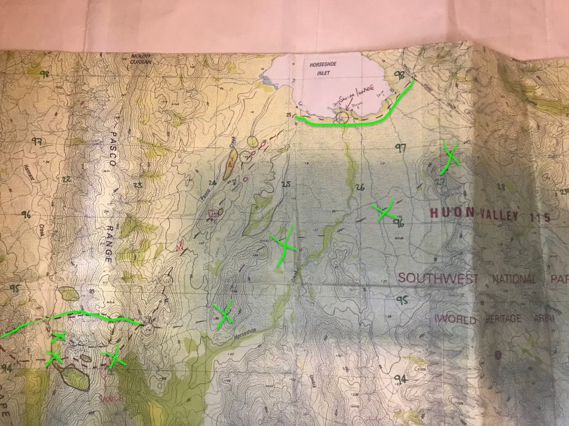
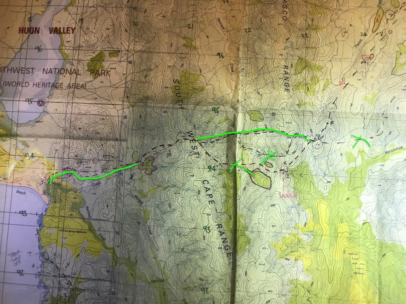
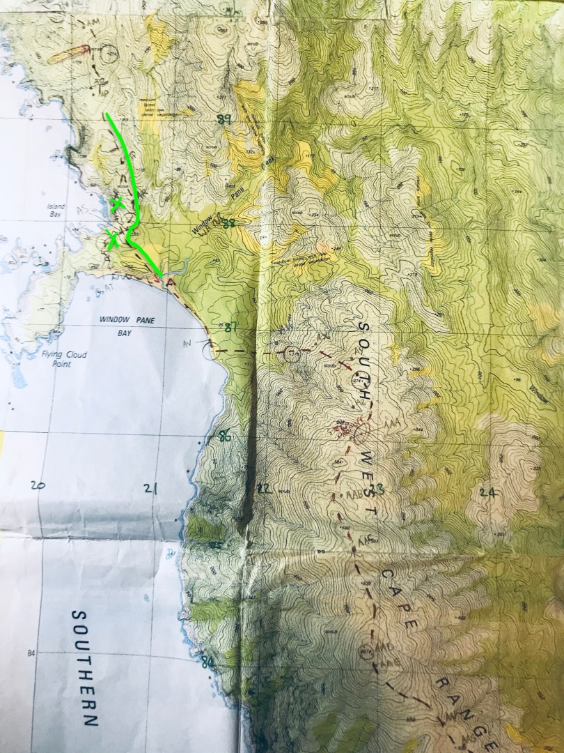
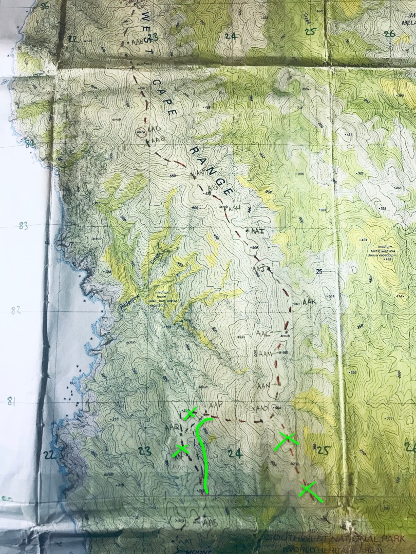
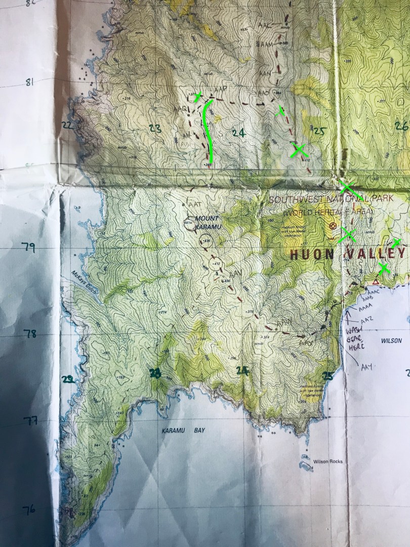
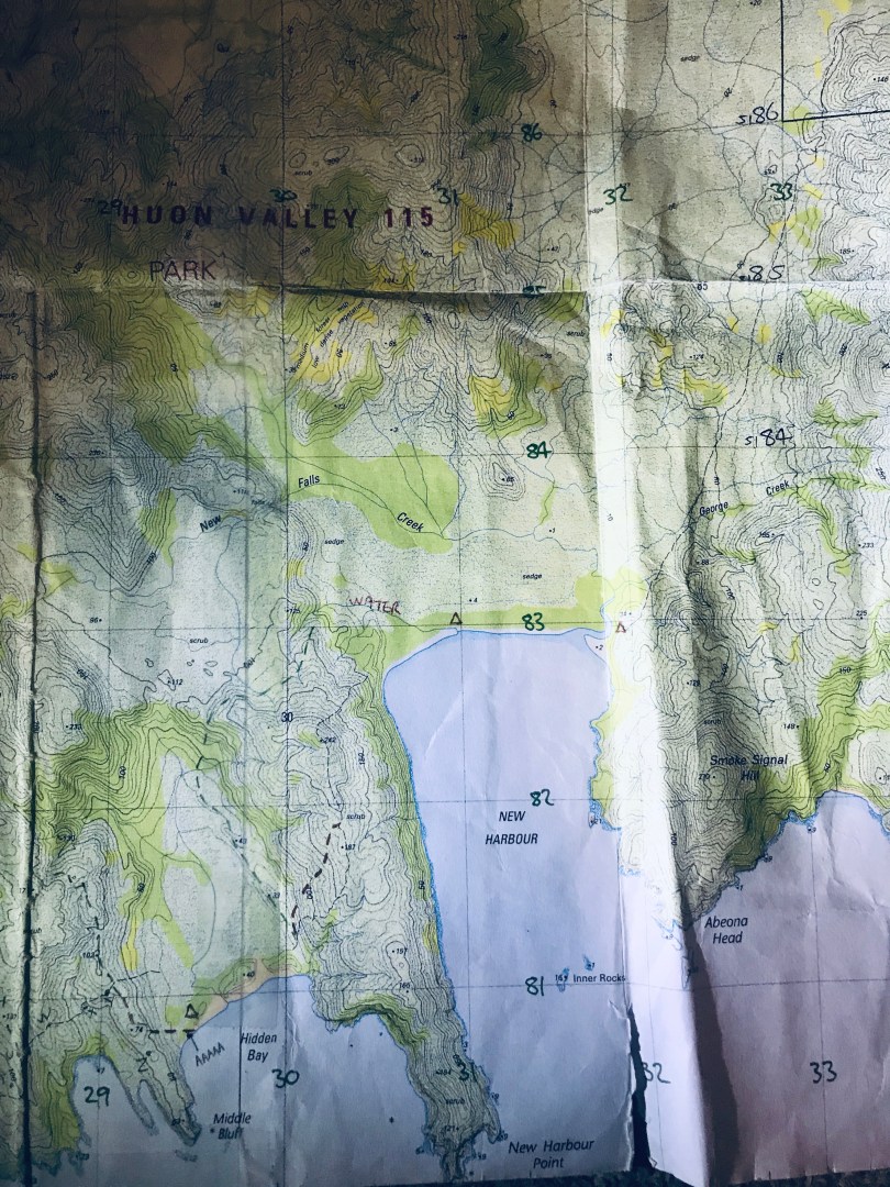
Post script: lots of people get in touch with me about sharing maps of the route and I’m happy to share. I’ll get around to putting together some high quality scans and posting them here but for now… here are some photos of my maps with mark ups – hope this helps you out.
I marked up the maps pre-trip but we made a few changes along the way. Green x’s indicate marked routes not taken. Solid green lines and the original map mark ups show the route actually taken.


Hi Mick,
Your trip sounds pretty awesome! I’m planning on doing a trip similar to this with others next month… Do you have an email I could get in touch with you on to pick your brain?
Jess 🙂
Hi Mick,
Don’t suppose you have GPS tracks of the route you took that you’d make available?
Thanks
Hi Julie, no I don’t but I have the map I used with the route hand drawn. I could take some pics and send them to you, or you’re welcome to have the map itself for reference (it is photocopies of a few maps stuck together). I could snail mail it but don’t post your address here, email me at: mickbeckers@yahoo.com.au if you would like to see it. It’s a great trip. Challenging but highly rewarding. Mick
A truly amazing trip Mick. Imagine my surprise when I google the hike 7 years later and this account is the first thing that pops up!.Kaz (the teacher) and I were just talking about it last week when I dropped in to see her and baby number 3. Thanks for all the planning, motivation and those chocolate muffins!
Cheers, Chris (the Engineer) 🙂
A fantastic trip with a great crew. Seems like a lifetime ago.
That was a fantastic read Mick. Definitely has re invigorated my desire to do it. Just have to find a couple of travelling companions. Yes a shame there isnt a gpx file for your trip as I would of used it. Hopefully when i do it i can track it. Thankyou for sharing your experience. Cheers
Thanks Brent. That trip was a few years ago and there is bound to be a gpx file on the web somewhere by now. But if you do track it yourself and are willing to share that would be great. That is probably the number one question I get for this trip. Have fun out there.