

It has been a while between posts and I’ve finally found some time to pull together some stats from the trail as promised. Without further ado, let’s get stuck in.
| Trail Name: |
-Hotshot- |
|
| Start date: |
2 May 2018 |
Mexican border near Campo |
| Finish date: |
28 Aug 2018 |
Rainy Pass, 2.5 days from Canada trail closed due to wildfires |
| Total number of days: |
119 |
Typically takes 140 to 180 days |
| Number hiking days: |
109 |
|
| Number zero days: |
10 |
|
| Total distance travelled: |
2623 mile |
4,221 kilometers, equivalent of Darwin to Mallacoota via Sth Australia and east through Vic |
| Average daily distance hiked: |
24 miles / day |
38.5 km/day |
| Shortest daily distance: |
2.4 miles |
3.9 km |
| Longest daily distance: |
38.2 miles |
61.5 km |
| Number times hiking inebriated: |
2 |
1 x drunk; 1 x stoned |
| Elevation gain: |
489,418 ft |
Equivalent of climbing from Everest base camp to the summit 42.7 times |
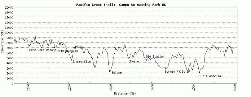
| Highest point: |
13,200 ft |
Forrester Pass |
| Elevation loss: |
488,411 ft |
|
| Lowest Point: |
180 ft |
Bridge of the Gods on Oregon-Washington Border |
| Average base weight (no food or water): |
15 pound |
Equivalent to 7 kg |
| Heaviest weight carried: |
40 pounds?? Hard to judge |
Entering the Sierras from Kennedy Meadows with a bear canister, 9 days food, ice axe, ice spikes and new tent. |
| Number of resupplies: |
32 |
|
| Average number days between resupplys: |
3 |
|
| Biggest number of days between resupply: |
9 days food |
Kennedy Meadows to Muir Trail Ranch |
| Number resupply boxes sent: |
10 |
|
| Worst resupply miscalculations |
Muir Trail Ranch Cascade Locks to Trout Lake |
Sent 4 days food ahead for a massive price – only needed 1.5 days.
1 day short. Ran out of food. |
| Number beers from trail angels: |
25+ (lost count) |
|
| Pairs of shoes worn out: | 5 | |
| Number of showers taken: |
22 over 4 months |
|
| Longest time between clothes wash: |
10 days |
|
| Favourite sections: | Sierras, North Cascades, Glacier NP, Goat Rocks Wilderness | |
| Least favourite sections: | The desert especially Tehachapi to Walker Pass, LA Aqueduct, southern Oregon, lava fields | |
| Number hospital visits: |
0 |
|
| Number times passed out: |
1 |
|
| Number times thrown up: |
2 |
|
| Foods can no longer stomach: | Packet Tuna, instant mashed potato, peanut butter, beef jerky | |
| Interesting fact: | More people have summited Everest this year than have finished the PCT | |
DAILY DISTANCE:

|
DAY |
DATE |
MILE START |
MILE FINISH |
EXTRA MILES |
DAILY MILEAGE |
DAILY KM’s |
TOTAL MILES |
|
|
1 |
2 May |
0.0 |
20.0 |
0 |
20.0 |
32.2 |
20.0 |
Lake Morena |
|
2 |
3 May |
20 |
37.2 |
0 |
17.2 |
27.7 |
37.2 |
|
|
3 |
4 May |
37.2 |
56.0 |
0 |
18.8 |
30.3 |
56.0 |
Mt Laguna |
|
4 |
5 May |
56.0 |
74.4 |
0 |
18.4 |
29.6 |
74.4 |
|
|
5 |
6 May |
74.4 |
94.4 |
0 |
20.0 |
32.2 |
94.4 |
|
|
6 |
7 May |
94.4 |
109.5 |
0 |
15.1 |
24.3 |
109.5 |
Warner Springs |
|
7 |
8 May |
109.5 |
131.4 |
0 |
21.9 |
35.2 |
131.4 |
|
|
8 |
9 May |
131.5 |
151.8 |
0 |
20.3 |
32.7 |
151.7 |
Idyllwild |
|
9 |
10 May |
151.8 |
151.8 |
0 |
0.0 |
0.0 |
151.7 |
Idyllwild Zero |
|
10 |
11 May |
151.8 |
190.5 |
0 |
38.7 |
62.3 |
190.4 |
San Jacinto |
|
11 |
12 May |
190.5 |
214.1 |
0 |
23.6 |
38.0 |
214.0 |
|
|
12 |
13 May |
214.1 |
239.9 |
0 |
25.8 |
41.5 |
239.8 |
|
|
13 |
14 May |
239.9 |
256.2 |
0 |
16.3 |
26.2 |
256.1 |
|
|
14 |
15 May |
256.2 |
266.1 |
0 |
9.9 |
15.9 |
266.0 |
Big Bear City |
|
15 |
16 May |
266.1 |
292.4 |
0 |
26.3 |
42.3 |
292.3 |
|
|
16 |
17 May |
292.4 |
318.0 |
0 |
25.6 |
41.2 |
317.9 |
|
|
17 |
18 May |
317.9 |
341.9 |
0 |
24.0 |
38.6 |
341.9 |
Cajon Pass |
|
18 |
19 May |
341.9 |
364.4 |
0 |
22.5 |
36.2 |
364.4 |
|
|
19 |
20 May |
364.3 |
369.3 |
0 |
5.0 |
8.0 |
369.4 |
Wrightwood Nero |
|
20 |
21 May |
369.3 |
369.3 |
0 |
0.0 |
0.0 |
369.4 |
Wrightwood Zero |
|
21 |
22 May |
369.3 |
389.1 |
0 |
19.8 |
31.9 |
389.2 |
|
|
22 |
23 May |
389.2 |
418.6 |
4.8 |
34.2 |
55.0 |
423.4 |
|
|
23 |
24 May |
418.6 |
444.3 |
0 |
25.7 |
41.4 |
449.1 |
Acton KOA |
|
24 |
25 May |
444.3 |
454.5 |
0 |
10.2 |
16.4 |
459.3 |
Agua Dulce / Hiker Heaven |
|
25 |
26 May |
454.5 |
478.2 |
0 |
23.7 |
38.1 |
483.0 |
Casa de Luna |
|
26 |
27 May |
478.2 |
504.6 |
0 |
26.4 |
42.5 |
509.4 |
|
|
27 |
28 May |
504.6 |
534.8 |
0 |
30.2 |
48.6 |
539.6 |
Hiker Town / LA Aquaduct |
|
28 |
29 May |
534.8 |
558.0 |
0 |
23.2 |
37.3 |
562.8 |
|
|
29 |
30 May |
558.0 |
566.4 |
0 |
8.4 |
13.5 |
571.2 |
Tehachapi |
|
30 |
31 May |
566.4 |
566.4 |
0 |
0.0 |
0.0 |
571.2 |
Tehachapi Zero |
|
31 |
1 Jun |
566.5 |
592.9 |
0 |
26.4 |
42.5 |
597.6 |
|
|
32 |
2 Jun |
592.9 |
616.0 |
0 |
23.1 |
37.2 |
620.7 |
|
|
33 |
3 Jun |
616.0 |
643.5 |
0 |
27.5 |
44.3 |
648.2 |
|
|
34 |
4 Jun |
643.5 |
654.3 |
0 |
10.8 |
17.4 |
659.0 |
Ridgecrest in and out |
|
35 |
5 Jun |
654.3 |
680.8 |
0 |
26.5 |
42.6 |
685.5 |
|
|
36 |
6 Jun |
680.8 |
702.2 |
0 |
21.4 |
34.4 |
706.9 |
Kennedy Meadows South |
|
37 |
7 Jun |
702.2 |
704.6 |
0 |
2.4 |
3.9 |
709.3 |
Kennedy Meadows Nero |
|
38 |
8 Jun |
704.6 |
729.6 |
0 |
25.0 |
40.2 |
734.3 |
|
|
39 |
9 Jun |
729.6 |
750.8 |
0 |
21.2 |
34.1 |
755.5 |
Chicken Lake |
|
40 |
10 Jun |
750.8 |
763.3 |
1 |
13.5 |
21.7 |
769.0 |
Crabtree Meadow |
|
41 |
11 Jun |
763.3 |
774.7 |
15 |
26.4 |
42.5 |
795.4 |
Mt Whitney / Tyndall Creek |
|
42 |
12 Jun |
774.7 |
789.0 |
0 |
14.3 |
23.0 |
809.7 |
Forrester Pass |
|
43 |
13 Jun |
789.0 |
811.3 |
0 |
22.3 |
35.9 |
832.0 |
Glen Pass / Pinchot Pass |
|
44 |
14 Jun |
811.3 |
832.4 |
0 |
21.1 |
34.0 |
853.1 |
Mather Pass |
|
45 |
15 Jun |
832.4 |
857.7 |
0 |
25.3 |
40.7 |
878.4 |
Muir Pass / Evolution Creek |
|
46 |
16 Jun |
857.7 |
880.6 |
0 |
22.9 |
36.9 |
901.3 |
Seldon Pass / MTR |
|
47 |
17 Jun |
880.6 |
906.6 |
0 |
26.0 |
41.8 |
927.3 |
Red Meadows / Mammoth Lakes |
|
48 |
18 Jun |
906.6 |
906.6 |
0 |
0.0 |
0.0 |
927.3 |
Mammoth Zero |
|
49 |
19 Jun |
906.6 |
933.0 |
0 |
26.4 |
42.5 |
953.7 |
Donohue Pass |
|
50 |
20 Jun |
933.0 |
957.3 |
0 |
24.3 |
39.1 |
978.0 |
Tuolumne Meadows |
|
51 |
21 Jun |
957.3 |
982.3 |
0 |
25.0 |
40.2 |
1003.0 |
Stubblefield Canyon |
|
52 |
22 Jun |
982.3 |
1006.8 |
0 |
24.5 |
39.4 |
1027.5 |
|
|
53 |
23 Jun |
1006.8 |
1027.3 |
0 |
20.5 |
33.0 |
1048.0 |
Kennedy Meadows North / Near East Fork Carson River |
|
54 |
24 Jun |
1027.3 |
1053.2 |
0 |
25.9 |
41.7 |
1073.9 |
Eagle Creek |
|
55 |
25 Jun |
1053.2 |
1079.3 |
0 |
26.1 |
42.0 |
1100.0 |
Upper Truckee Creek |
|
56 |
26 Jun |
1079.3 |
1090.1 |
0 |
10.8 |
17.4 |
1110.8 |
South Lake Tahoe |
|
57 |
27 Jun |
1090.1 |
1090.1 |
0 |
0.0 |
0.0 |
1110.8 |
South Lake Tahoe Zero |
|
58 |
28 Jun |
1090.1 |
1090.1 |
0 |
0.0 |
0.0 |
1110.8 |
South Lake Tahoe Zero |
|
59 |
29 Jun |
1090.1 |
1112.6 |
0 |
22.5 |
36.2 |
1133.3 |
Phipps Creek |
|
60 |
30 Jun |
1112.6 |
1140.9 |
0 |
28.3 |
45.5 |
1161.6 |
Squaw Valley |
|
61 |
1 Jul |
1140.9 |
1162.4 |
0 |
21.5 |
34.6 |
1183.1 |
Donner Ski Ranch / Soda Springs / near Basin Peak Spring |
|
62 |
2 Jul |
1162.4 |
1187.0 |
0 |
24.6 |
39.6 |
1207.7 |
|
|
63 |
3 Jul |
1187.0 |
1195.4 |
1.4 |
9.8 |
15.8 |
1217.5 |
Sierra City |
|
64 |
4 Jul |
1195.4 |
1227.1 |
1.4 |
33.1 |
53.3 |
1250.6 |
|
|
65 |
5 Jul |
1227.1 |
1258.8 |
0 |
31.7 |
51.0 |
1282.3 |
|
|
66 |
6 Jul |
1258.8 |
1286.5 |
2 |
29.7 |
47.8 |
1312.0 |
Beldon |
|
67 |
7 Jul |
1286.5 |
1318.0 |
0 |
31.5 |
50.7 |
1343.5 |
Carter Creek |
|
68 |
8 Jul |
1318.0 |
1331.3 |
0 |
13.3 |
21.4 |
1356.8 |
Chester |
|
69 |
9 Jul |
1331.3 |
1350.3 |
0 |
19.0 |
30.6 |
1375.8 |
Warner Valley Camp |
|
70 |
10 Jul |
1350.3 |
1384.7 |
0 |
34.4 |
55.4 |
1410.2 |
Old Station |
|
71 |
11 Jul |
1384.7 |
1414.0 |
0 |
29.3 |
47.2 |
1439.5 |
Hat Creek Rim / Burney |
|
72 |
12 Jul |
1414.0 |
1414.0 |
0 |
0.0 |
0.0 |
1439.5 |
Burney Zero |
|
73 |
13 Jul |
1414.0 |
1443.0 |
1.4 |
30.4 |
48.9 |
1469.9 |
Burney Falls |
|
74 |
14 Jul |
1443.0 |
1470.9 |
0 |
27.9 |
44.9 |
1497.8 |
Ash Camp / McCloud River |
|
75 |
15 Jul |
1470.9 |
1501.2 |
0 |
30.3 |
48.8 |
1528.1 |
I5 / Soda Creek Road / Dunsmuir |
|
76 |
16 Jul |
1501.2 |
1519.9 |
0 |
18.7 |
30.1 |
1546.8 |
|
|
77 |
17 Jul |
1519.9 |
1552.8 |
0 |
32.9 |
52.9 |
1579.7 |
Near Little Trinity River |
|
78 |
18 Jul |
1552.8 |
1586.1 |
0 |
33.3 |
53.6 |
1613.0 |
Near Bingham Lake |
|
79 |
19 Jul |
1586.1 |
1618.5 |
0 |
32.4 |
52.1 |
1645.4 |
Summit Lake Junction |
|
80 |
20 Jul |
1618.5 |
1649.5 |
0 |
31.0 |
49.9 |
1676.4 |
Grider Creek |
|
81 |
21 Jul |
1649.5 |
1679.3 |
0 |
29.8 |
48.0 |
1706.2 |
Seiad Valley |
|
82 |
22 Jul |
1679.3 |
1695 |
20 |
35.7 |
57.5 |
1741.9 |
California! Hendrix Fire Closure |
|
83 |
23 Jul |
1708.2 |
1718.9 |
0 |
10.7 |
17.2 |
1752.6 |
Ashland |
|
84 |
24 Jul |
1718.9 |
1718.9 |
0 |
0.0 |
0.0 |
1752.6 |
Ashland Zero |
|
85 |
25 Jul |
1718.9 |
1718.9 |
0 |
0.0 |
0.0 |
1752.6 |
Ashland Zero |
|
86 |
26 Jul |
1718.9 |
1744.3 |
0 |
25.4 |
40.9 |
1778.0 |
Lake Hyatt |
|
87 |
27 Jul |
1744.3 |
1773.2 |
2 |
30.9 |
49.7 |
1808.9 |
Fish Lake |
|
88 |
28 Jul |
1773.2 |
1804.3 |
2 |
33.1 |
53.3 |
1842.0 |
Sevenmile Trail Junction |
|
89 |
29 Jul |
1804.3 |
1823 |
13.4 |
32.1 |
51.7 |
1874.1 |
Mazama Village / Crater Lake |
|
90 |
30 Jul |
1839.2 |
1872.1 |
0 |
32.9 |
52.9 |
1907.0 |
Six Horse Spring |
|
91 |
31 Jul |
1872.1 |
1906.6 |
0 |
34.5 |
55.5 |
1941.5 |
Shelter Cove |
|
92 |
1 Aug |
1906.6 |
1933.2 |
0 |
26.6 |
42.8 |
1968.1 |
Three Sisters Wilderness |
|
93 |
2 Aug |
1933.2 |
1967.9 |
0 |
34.7 |
55.8 |
2002.8 |
|
|
94 |
3 Aug |
1967.9 |
1995.1 |
0 |
27.2 |
43.8 |
2030.0 |
Big Lake Youth Camp |
|
95 |
4 Aug |
1995.1 |
2010.9 |
0 |
15.8 |
25.4 |
2045.8 |
Sisters / Jefferson Wilderness |
|
96 |
5 Aug |
2010.9 |
2039.9 |
0 |
29.0 |
46.7 |
2074.8 |
Mt Jefferson |
|
97 |
6 Aug |
2039.9 |
2075.8 |
0 |
35.9 |
57.8 |
2110.7 |
Ollalie Lake / Timothy Lake |
|
98 |
7 Aug |
2075.8 |
2096.9 |
0 |
21.1 |
34.0 |
2131.8 |
Timberline Lodge |
|
99 |
8 Aug |
2096.9 |
2123.8 |
0 |
26.9 |
43.3 |
2158.7 |
|
|
100 |
9 Aug |
2123.8 |
2146.8 |
0 |
23.0 |
37.0 |
2181.7 |
Cascade Locks |
|
101 |
10 Aug |
2146.8 |
2146.8 |
0 |
0.0 |
0.0 |
2181.7 |
Cascade Locks Zero |
|
102 |
11 Aug |
2146.8 |
2176.7 |
0 |
29.9 |
48.1 |
2211.6 |
|
|
103 |
12 Aug |
2176.6 |
2214.8 |
0 |
38.2 |
61.5 |
2249.8 |
|
|
104 |
13 Aug |
2214.7 |
2232.5 |
0 |
17.8 |
28.6 |
2267.6 |
Trout Lake |
|
105 |
14 Aug |
2232.5 |
2260.7 |
0 |
28.2 |
45.4 |
2295.8 |
|
|
106 |
15 Aug |
2260.7 |
2278.6 |
10 |
27.9 |
44.9 |
2323.7 |
Goat Rocks |
|
107 |
16 Aug |
2294.9 |
2304.7 |
10 |
19.8 |
31.9 |
2343.5 |
White Pass |
|
108 |
17 Aug |
2304.7 |
2327.8 |
0 |
23.1 |
37.2 |
2366.6 |
Near Three Way Peak |
|
109 |
18 Aug |
2327.8 |
2354.2 |
0 |
26.4 |
42.5 |
2393.0 |
|
|
110 |
19 Aug |
2353.2 |
2384.3 |
0 |
31.1 |
50.1 |
2424.1 |
Mirror Lake |
|
111 |
20 Aug |
2384.3 |
2393.1 |
0 |
8.8 |
14.2 |
2432.9 |
Snoqualmie Nero |
|
112 |
21 Aug |
2393.1 |
2417.7 |
0 |
24.6 |
39.6 |
2457.5 |
|
|
113 |
22 Aug |
2417.7 |
2444.7 |
0 |
27.0 |
43.5 |
2484.5 |
Talus Lake |
|
114 |
23 Aug |
2444.7 |
2464.2 |
0 |
19.5 |
31.4 |
2504.0 |
Stevens Pass / Skykomish |
|
115 |
24 Aug |
2464.2 |
2493.5 |
0 |
29.3 |
47.2 |
2533.3 |
Lake Sally Ann |
|
116 |
25 Aug |
2493.5 |
2524.6 |
0 |
31.1 |
50.1 |
2564.4 |
Milk Creek |
|
117 |
26 Aug |
2524.6 |
2551.8 |
2.5 |
29.7 |
47.8 |
2594.1 |
Cloudy Pass |
|
118 |
27 Aug |
2571.9 |
2577.0 |
9.5 |
14.6 |
23.5 |
2608.7 |
Stehekin |
|
119 |
28 Aug |
2577.0 |
2591.1 |
0 |
14.1 |
22.7 |
2622.8 |
Rainy Pass – Trail closed from here due to wildfires |
|
2622.8 |
4221.0 |
RESUPPLY STRATEGY:


| TOWN |
No. Days resupplied for |
Buy or Mail |
If mailed, sent to |
| San Diego |
2.5 |
Buy |
|
| Mt Laguna |
4 |
Buy |
|
| Warner Springs |
2 |
Buy |
|
| Idyllwild |
4 |
Buy |
|
| Big Bear City |
5 |
Buy |
|
| Wrightwood |
4 |
Buy |
|
| Agua Dulce |
5 |
Buy |
|
| Tehachapi |
3.5 |
Buy |
|
| Ridgecrest |
2.5 |
Buy |
|
| Kennedy Meadows South |
9 |
|
Grumpy Bears Retreat |
| Muir Trail Ranch |
1.5 |
|
Muir Trail Ranch. I sent 4 days, only needed 1.5 |
| Mammoth Lakes |
2 |
Buy |
|
| Tuolumine Meadows |
3 |
Buy |
|
| Kennedy Meadows North |
4 |
Buy |
|
| Sth Lake Tahoe |
2.5 |
Buy |
|
| Soda Springs |
1.5 |
Buy |
|
| Sierra City |
5 |
|
Sierra Country Store |
| Chester |
3 |
Buy |
|
| Burney |
3 |
Buy |
|
| Dunsmuir |
5 |
Buy | |
| Seiad Valley |
2.5 |
Buy |
|
| Ashland |
3.5 |
Buy |
|
| Mazama Village |
2 |
|
Xanterra Mazama Village Camp Store |
| Shelter Cove |
4 |
Mail / Buy |
Shelter Cove Resort |
| Sisters |
1.5 |
Buy |
|
| Olallie Lake |
1 |
Buy |
|
| Timberline Lodge |
2.5 |
|
Timberline Lodge |
| Cascade Locks |
3 |
Buy |
|
| Trout Lake |
3.5 |
|
Trout Lake Grocery |
| White Pass |
4 |
|
Kracker Barrel |
| Snoqualmie Pass |
3 |
|
Summit Inn Hotel |
| Skykomish |
5 |
|
Cascada Inn |
| Winthrop |
3 |
Buy |
Didn’t need to resupply as trail closed from Rainy Pass |
Base weight:
Starting weight

Sierra weight: heavier jacket and rain pants, ice axe, micro spikes, fleece & bear can.

Finish weight:


Wow. This is awesome! I’m pretty proud of myself when I walk the 2 miles to work when it’s 95 degrees. 😄 Kudos to you!