

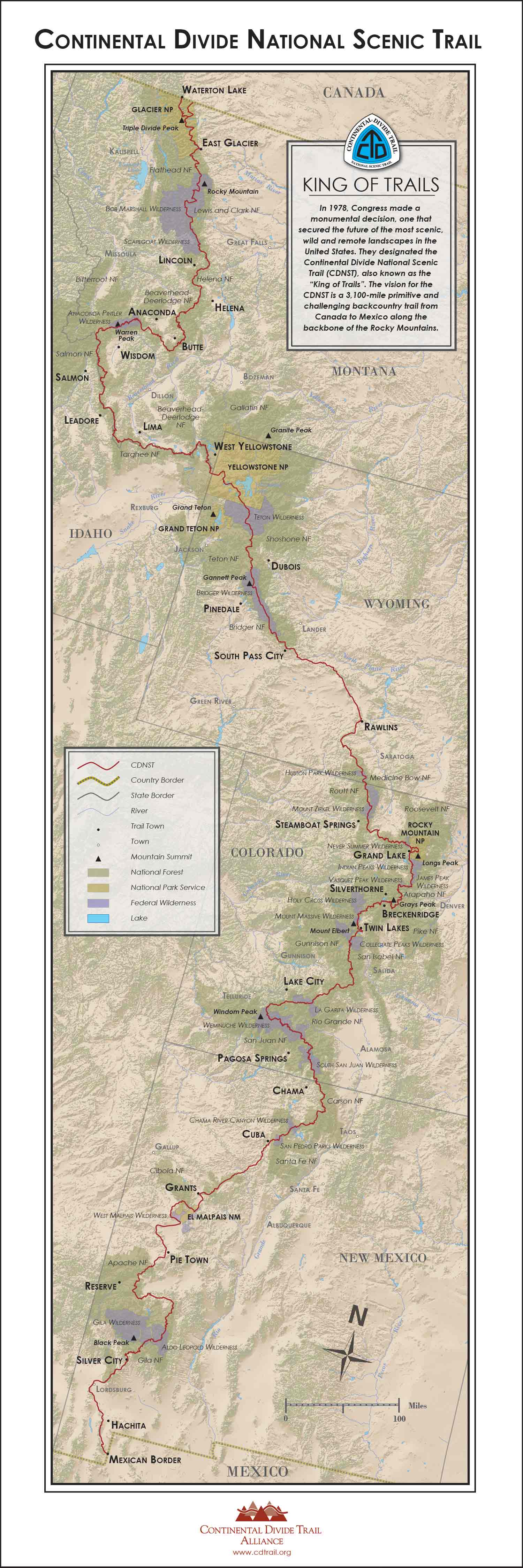
It has been eons since my last post and with four weeks to go before flying to the United States to embark on another epic adventure it is about time I pulled by myself into gear to spruik it. As the title suggests, you know which trail I’m headed too and from the opening sentence what country it’s located. Let me tell a little more. Established in 1978 the Continental Divide Trail (CDT) is a roughly 3,100 mile (4,989 km) trail stretching from the US-Mexican border near the sleepy town of Hachita, New Mexico roughly following the Continental Divide through the Rocky Mountains all the way to Waterton Lake on the US-Canadian border. I say it’s roughly 3,100 miles because unlike other long trails the CDT is more a choose your own adventure route with many alternate sections available. Some hikers will cut huge sections off to hike around 2,700 miles, while others choose to follow the offical route, or what hikers call the ‘Red Line’ to make up the full distance. Me, I’ll be in between here somewhere choosing to take a bunch of alternatives off the Red Line for some side quests before rejoining and continuing north. (Why is it called the Red Line? Because that is the colour of the trail on the main navigation App most hikers use called FarOut).
The CDT is one of three US National Scenic Trails making up what is known in the hiking community as the Triple Crown; the other two trails being the Appalachian Trail (AT) and the Pacific Crest Trail (PCT), the PCT being the last really long trail I completed back in 2018. The CDT is the longest, remotest and logically challenging of the 3 trails. I can’t wait.
Snaking its way through New Mexico, Colorado, Wyoming, Idaho & Montane the CDT offers a real mixed bag of terrain and challenges, and of course gorgeous scenery. Formed single track through desert country in New Mexico can quickly fade to nothing more than a few trail marker posts off in the distance, leaving hikers to pick the line of least resistance though cactus and rock. Water carries in the desert will be heavy, in the range of 4 to 5 litres at a time, moving from one water source to the next. Sharing water with cows is not unheard of, with hikers collecting it from cattle troughs, challenging water filters to continue functioning to stave off Giardia and the like. But it doesn’t take long, may a week or so, to be in the cover of trees and the foothills forests, where water becomes more plentiful.
A major alternate that I will take is along the Gila River, walking through the river gorge for several days with towering cliffs above and more than 100 river crossings; plus a side quest to see the Gila Cliff Dwellings, used for thousands of years by Native American tribes and remaining preserved today.
With 30% of the CDT remaining to be constructed, much of the route needs to skirt around private property leading hikers along long stretches of abandoned roads and busy highways at times, making for fast hiking but a mind fuck to stay sane and keep moving forward. Most of these sections are in the first half of New Mexico.
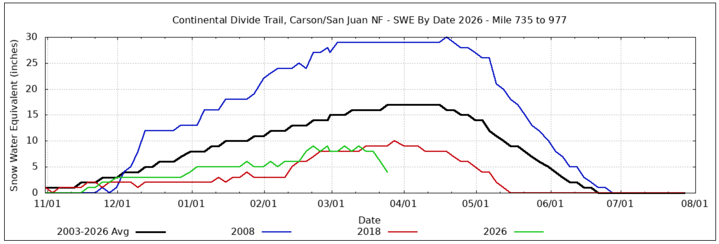
In a typical year there is no need to through rush New Mexico as snow levels in Colorado can still be high. Push too quickly and you have to hold up in town for the snow to melt for several weeks. I don’t have the luxury of being able to wait for weeks at a time so opted for a later start to the trail than most of the hiker bubble that typically leaves in mid April. With many kilometres of trail running under the feet over the past 12 months a later start won’t hurt and I’ll be able to push through New Mexico relatively quickly. As a bonus, 2026 has seen near record low snow levels in Colorado and I’m expecting most of that State to be relatively snow free by the time I reach the border.
Snow would normally be the main consideration for Colorado but their are others. Most of the state is above 10,000 feet in elevation and afternoon lightning storms are typical through summer. This requires careful timing over long exposed mountain ridges before storms hit or risk dodging lightning bolts while carrying lightning rods in the form of walking poles in hands and maybe an ice axe strapped to the pack. Colorado will be hard for sure. The scenery through the San Juans will more than make up for that.
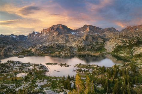
Pushing into Wyoming again brings diverse landscapes. The expansive, treeless Great Basin, kicks this state off, a windswept place where shade does exist and long water carries come back into play. This is the time to push big miles. I’m most looking forward to the Wind River Range further along and an alternate route through the Cirque of the Towers. Breathtaking scenery. It is entering The Winds or just before that I’ll enter grizzly bear country. From this point on bear spray is a must and will hang off the front of my pack.
A routine of cooking dinner on trail before walking on for another 30-60 minutes before setting up camp will also start. Exiting The Winds, the trail makes its way through Yellowstone National Park where leaving the marked path is not an option for risk of breaking through a thin crust of ground into boiling hot geothermal pools.
Exiting Wyoming the CDT follows the border of both Idaho and Montana for a length, much of the trail on the true continental divide. Big Sky Country. The mountains will be big and my legs solid balls of muscle by now ready power up anything thrown at me. I’ll be tired and wanting to finish up but still longing to travel through places like the Bitterroot Mountains, Bob Marshall Wilderness before, if all goes to plan, passing through Glacier National Park to finish at the border at Waterton Lake.
I do plan on blogging this trip however there will be a need to conserve battery power on this one so a little undecided if it will be a day by day blow or shift more to a section by section blog. We’ll see. There is only one way to know though and that is to subscribe and follow along with me.
Wish me luck.
